Thursday, April 1, 2010
Day 14 3/20
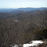
Started the morning with breakfast at the restaurant – sweet potato griddle cakes (gooey), eggs and sausage. The Nantahala River is about 44 degrees. Climbed from 1700' at the rive to 5062' on Cheoah Bald – moderate terrain with a few steep bits. Nice view of the river from the Jump Up. I could even hear the tourist train's whistle. Had lunch on Swim Bald (wooded). First register in a shelter in NC at Sassafras Gap. Sofa caught up to me there – he is starting to have shin splints. The view from Cheoah Bald south was lovely, especially thanks to the folding lawn chair on top. Mountains to the horizon were blue and hazy. Steep ridges, pointy peaks. I hiked 10.5 miles to Locust Cove Gap to tent camp there.
Subscribe to:
Post Comments (Atom)


For anyone who is curious why places in the mountains are called "cove", it is referring to the sheltered forest ecosystem in these areas. Sometimes a bedrock basin collects and traps nutrient-rich soils derived from weathered rock, which give rise to lush stands of big trees. Another theory suggests that these areas were sheltered by the surrounding mountains during the last ice age, and were not bulldozed by the glaciers, allowing the soils to develop and the trees to remain.
ReplyDelete