April 1 (Day 26)
A brief conversation with a couple day hikers brought out an excited “Oh! The blueberry pie at.... that place...” “Yeah, Helen's.”
The ridge line over Big Fire Scald Bald was rocky and exposed ledge. Trail notes warned of an 8 foot vertical scramble requiring the use of hands. Emily met a SOBO (SOuth BOund hiker) who earnestly advised that she avoid it by hiking the bad weather bypass. Emily did not follow his advice. That night she wrote in the Shelton Graves register, “That was a nice taste of NH and ME, but where was the so-called 'scramble'?” Not trying to be a wiseguy, but just letting NOBOs (NOrth BOund hikers) know what's ahead.
April 2 & 3
“Why am I sweating when I'm going DOWNhill?” Someone said it was 83 degrees; another source claimed it was 87. Early spring flowers are blooming, but there are no leaves yet on the trees. When she needed to rest, she'd find a tree with a big enough shadow that she could be entirely out of the sun. After a while, she said, “It felt like my shadow didn't want to leave the shade.” and, thinking further of Peter Pan, “Wouldn't it be nice if we could hike in our own shadow all day!” Since that's not an option, daydreams of ice cubes, ice cream, and SCUBA diving in the Gulf Of Maine kept Emily hiking through the heat.
Spring weather on the AT is just as changeable as the terrain. Hiking over Big Bald was so windy that, leaning into the wind, she could feel her pack lurching sideways. Brown grass, brambles and hawthorns reminder her of Oregon. She spent the night in Erwin, TN.
April 4
Today's hike ended “kinda like Maine”. Emily camped on Unaka Mt. Covered with red spruce that “smelled really nice.” There were some scraggly blowdowns to negotiate: “You know what THEY'RE like!”
April 5
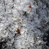
This 18.9 mile day ended after a 2000 foot ascent to the highest shelter (6,275 feet) on the AT, Roan High Knob, TN. The last mile of trail was covered with a foot and a half of rotten snow over an inch and a half of flowing water. [We spelled that out so there would be no doubt in your mind about how wet and messy it was!] Since she couldn't avoid breaking through it, Emily channeled her frustration into “stomping the snow to oblivion” thinking it might be helpful to hikers following her.
April 6
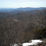
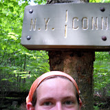
Leaving Roan High Knob was nasty, cold and messy on a muddy trail that had more water running down it than some of the streams she surveyed in OR last summer. It seemed there were blowdowns every ten steps! Grassy balds later in the day gave a reward of really nice 360 views. Emily investigated a box of pamphlets promoting an adopt-a-goat effort: when the grass turns green goats are brought here to graze, preserving the grassy balds by preventing blackberries from taking over. That night she camped on the NC/TN State Line at Doll Flats [Editor's note: The AT runs along the border of NC and TN for many miles, often crossing back and forth. Emily is not back tracking or lost, people just thought the mountains made a nice state border at that point.]
April 7
Our favorite experienced map reader and trail finder was confused! The original AT went straight up over and down the ridge lines. Apparently the atmosphere in the neighborhood of the Buck Mt Road gave cause for relocation of the trail, accomplished with a section of “ridiculous” switchbacks that cross and re-cross the original trail. The problem is that the original blazes aren't covered up, so a hiker can find the familiar white blaze in ALL directions at some intersections. Sometimes a few “skinny little sticks” were discernible as blocking the old pathway. Emily's guide was to know whether she should be going uphill or down, rather than going along with other hikers.
April 8
The day brought some rain, but Laurel Fork Falls is “really really pretty.” By the end of this day, Emily had hiked a total of more than 400 miles. This night at Laurel Fork shelter was her first encounter with inconsiderate hikers: oooh and is she ever grumpy when her sleep is interrupted for no good reason! Bears beware, there's a sleep deprived Emily in these parts.
April 9, 10, 11
Emily took it easy these days: she wanted to be in Damascus, VA on a Monday rather than a Saturday or Sunday, because of business hours. So in spite of the long, flat ridge line from Erwin or Hampton TN, which bears the nickname “the Tennessee Turnpike,” she didn't cruise. Some call it “the Damascus Dash.” Trail gossip said that one guy pushed 50 miles on 12 Snickers bars and ended up paying for it with an unplanned day in Damascus. Since Emily's not traveling that fast, she's spotted turkeys, deer, a barred owl, a snake, and robins, juncos, wrens, and thrushes. She can't name the flowers, but several remind her of Maine varieties.
April 13
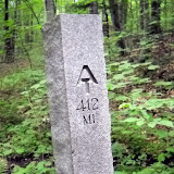
After a refreshing resupply in Damascus, VA, 463.5 miles from the starting point of Springer Mt GA, Emily is “heading out to rack up some big mile days!”
Subscribe to:
Post Comments (Atom)


Emily is a glacial hiker, accustomed to terrain that has been recently sculpted by glacial ice. In her case, northern New England was covered with ice about 10,000 years ago. The ice sheet and glaciers scraped a lot of material off the mountains and dumped it on the coast. The hiking in this area is on the scarred terrain that was left behind: barren rock, broken up by frost and weather, covered in wet, slimy vegetation and mucky, clay-rich soils at best. Although the peaks are not as dramatic as younger mountains, they are almost as difficult to climb because they are the gnarly, tough remnants of much larger mountains. Tough rocks make for tough hiking. During the last ice age, the ice sheet only reached as far south as mid-Pennsylvania (if I remember my geomorphology correctly), so Emily will eventually cross the border back into familiar terrain. Fewer rounded hills and deep coves, more boulder-strewn ledgy sections that stretch for miles, punctuated by knobby false peaks and interspersed with peat bogs. May the geologically uninformed rookies she's hiking with beware...it only gets harder!
ReplyDelete