Hey everyone,
Check out the January/February issue of AT Journeys (the ATC publication) for an article about the historic re-enactment on Katahdin! Kylie...you're in the photo, so make sure you check it out (I wish I had your e-mail/address)!
Tuesday, November 30, 2010
Tuesday, August 10, 2010
THANK YOU!!!
Now that my trip has reached an end, I want to thank everyone who helped me along the way. Everyone that I met in the trail community was so friendly and helpful! Thanks to everyone who sent me care packages along the way, or left words of encouragement on my blog site or with my parents. Just knowing that I had so many family and friends following my trip helped me through the tougher parts of the journey. Thanks to those who hiked with me and met me at road crossings, especially my parents. Throughout Maine I had personalized trail magic: they met me at every road doing the "trail magic hop", resupplying me, getting me dried out if it rained. Although I did the hiking, it's thanks to everyone who supported me that I made it all the way to Maine, and had fun along the way. And of course a HUGE thank you to Liz, my webmaster and blogger :-)
Monday, August 9, 2010
GAME 10
(Georgia to Maine, 2010 in hiker short-hand)
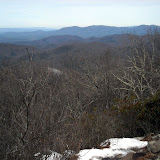
March 7 I stood on Springer Mountain looking north. August 6 I stood on Katahdin. 2,179.1 miles and 5 months of hiking through spectacular scenery, meeting wonderful people along the way. Many people hike the trail for profound reasons. In the words of Benton MacKaye, one of the founders of the trail, I hiked the trail “to walk, to see, and to see what I see”. Watching the seasons progress from winter to summer, from south to north, seeing the leaves unfurl, the flowers bloom, the mushrooms emerge. The first time I climbed Katahdin almost 10 years ago, and saw the white blazes headed south, I wanted to know what the trail looked like and what it passed through on the way to Georgia. Now, standing on Katahdin looking south, I know where the trail goes. I really enjoyed the hike, and I think the trail was a perfect length for me. I can't see myself doing another hike of this length, but I'm already reading about some shorter (maybe a month or so) long trails for my next excursion :-) However, right now I'm ready to move on to my next adventure—Newfoundland!
March 7 I stood on Springer Mountain looking north. August 6 I stood on Katahdin. 2,179.1 miles and 5 months of hiking through spectacular scenery, meeting wonderful people along the way. Many people hike the trail for profound reasons. In the words of Benton MacKaye, one of the founders of the trail, I hiked the trail “to walk, to see, and to see what I see”. Watching the seasons progress from winter to summer, from south to north, seeing the leaves unfurl, the flowers bloom, the mushrooms emerge. The first time I climbed Katahdin almost 10 years ago, and saw the white blazes headed south, I wanted to know what the trail looked like and what it passed through on the way to Georgia. Now, standing on Katahdin looking south, I know where the trail goes. I really enjoyed the hike, and I think the trail was a perfect length for me. I can't see myself doing another hike of this length, but I'm already reading about some shorter (maybe a month or so) long trails for my next excursion :-) However, right now I'm ready to move on to my next adventure—Newfoundland!
August 6, 2010
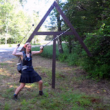
Up early to beat the crowds, Rob and I headed up the Hunt Trail for the last 5.2 miles of my Appalachian Trail thru-hike. The summit was in and out of clouds, but we had made arrangements with Pamola (Keeper of Katahdin, a creature with the head of a moose, wings and feet of an eagle, and torso of a man) for clear skies from 11 to 1, and he kept to his word. We met some thru-hikers coming down across the Tableland....including Picker!! It was really great to see him again. I hadn't seen him since Pearisburg, VA! At the summit Rob and I re-staged a historic photo of Myron Avery and his measuring wheel (I packed a converted bicycle wheel up the mountain with me), and attracted a LOT of attention. We came down via the Knife Edge and Dudley, probably the hardest way off the mountain, but it was fun.
100 miles to Katahdin
The last 100 miles of trail in Maine (the famed Wilderness) went quickly. I had hiked the section two years ago with Liz, so I remembered a lot of the trail, and I was in between thru-hiker bubbles (hiking alone). I had excellent hiking weather, watched the loons on numerous lakes, and even saw a bear! The last night I tented on the shore of a lake and watched the sun rise over the shoulder of Katahdin. It was magical. My folks all met me in Baxter State Park, where we waited a day for good weather. In the meantime my brother and I climbed Doubletop Mountain and went swimming at the natural rock slide at Ledge Falls on Nesowadnehunk Stream. We had many moose sightings, and watched a beaver swim up the stream across the falls, within 4 feet of us!!
Monday, August 2, 2010
15.1 Miles to Go
Emily is at Abol Bridge today...will do the next to last section tomorrow...Barb & Rob come Tuesday...looks like Mt. Katahdin will be later in the week to finish her 2,179 mile trek from Georgia!!!
Coming to you from the Appalachian Trail Cafe in Millinocket, Maine.
Coming to you from the Appalachian Trail Cafe in Millinocket, Maine.
Monday, July 26, 2010
Mountains of Maine
I had beautiful weather crossing the high peaks of Maine. Last time I hiked most of those peaks was up to 14 years ago (my first ever backpacking trip, over the Crockers and Sugarloaf!), so I had remembered the trail as being VERY tough. It definitely was rugged, but I had a lot of fun hiking through them. I saw a MOOSE on Spaulding Mountain ridge. I beat my dad to the trail work site just north of Rt. 27 near Stratton (and he only had to day hike 5 miles to the site. I walked 12 miles). We helped to install some new bog bridging with some other AMC/MATC (Maine Appalachian Trail Club) folks. It was fun to give back to the trail, while still on my thru-hike. My dad then joined me to cross Bigelow Mountain—my favorite in the state. We had gorgeous weather, but it was a little too hazy to see Katahdin. We even found the machete used by Myron Avery when doing trail work!! Myron Avery, of North Lubec, Maine, was one of the founding fathers of the Appalachian Trail. He is responsible for laying out most of the original trail in Maine, and for getting the trail into Maine in the first place (the northern terminus was originally going to be Mt. Washington, NH). Bigelow was Avery's favorite mountain, so when he passed away his family cemented his machete near the summit of Bigelow.
Flatlands of Maine
My dad hiked with me for about a week through the ponds and swamps. We heard lots of loons and saw lots of toads, frogs, and mushrooms. The blueberries are ripe—making a lovely addition to our morning oatmeal. There are amazingly few biting insects out this year. We stopped to admire several bogs and didn't get chewed up. We crossed the Kennebec River—a dangerous ford because of the hydroelectric dam upstream that can release large volumes of water. MATC has provided a canoe ferry (and ferryman) to help hikers across. We did have to ford the East and West Branches of the Piscataquis River...but they were easy. Knee deep, gentle current, warm water. I'm taking a zero day in Greenville with my parents before heading into the 100-mile Wilderness. I'm taking my time and enjoying the rest of my trip, so several of my northbound friends have caught up and passed me. It sounds like August 1 is a popular summit day, but I will be on Katahdin a few days after that.
100 Mile Wilderness
A remote stretch of trail accessed only by logging roads, the trail winds past several pretty ponds and waterfalls, crosses (fords) several streams, and climbs a couple 3000 foot mountains. I'm looking forward to my first view of Katahdin (from Gulf Hagas Mtn.), and watching the sunrise next to Katahdin over Rainbow Lake. My dad is meeting me part way through to resupply me, and then I'll hike up to Baxter State Park to join him and my mom and brother. Rob is planning to summit the Big K with me.
114.5 miles to go!!
114.5 miles to go!!
Saturday, July 24, 2010
July 12
Slackpacked (hiked with just lunch and rain gear) over Baldpate with beautiful weather. I'd forgotten how steep that mountain is! I met my parents at a road crossing to pick up my camping gear and hiked in to Surplus Pond for a quiet night. I woke up to a moose feeding in the pond, followed by swimming across the width of the pond. All the Sobos had warned us about how horrible the trail was on Moody Mountain. Last spring one side of the mountain slid off, and they have temporarily re-routed the trail around the slide. I was expecting the worst, but it was actually only a couple hundred feet of detour. The trail is still steep and eroded in places, but not as horrendous as I had heard. Hiked over Old Blue and Bemis on Thursday. The trail is ROUGH. Rocks, roots, mud. They need to install more bog bridging on the ridgeline! Met my parents at route 17 and slackpacked 14 miles with Moonpie and Doozy to route 4 through the muddy bogs. They even managed to fall in up to their waists in one bog (thanks to faulty bog bridges, and a lack of bog bridges). One last night in a campground with my parents, and then I'm on my own for the high peaks of Maine. I'll meet up with Dad right before climbing Bigelow Mountain (Sunday), and he'll hike with me for about a week (to Monson).
Saturday, July 17, 2010
July 9th - The Mahoosucs
I headed up into the rugged and remote Mahoosuc Range with Moonpie and Doozy. We got flooded out of the tent sites at Trident Col, but the rain let up part way through the next day. I hiked this section with my brother in 2003, but it seemed a lot easier this time around. Probably something to do with the 1900 miles of experience...The trail was still wet, rocky, rooty, and technically challenging. Crossed into State #14, MAINE!!!!! on July 10. I'm glad to be in my home state! Woke up on July 11 to SUNSHINE!! When I dropped down into the infamous Mahoosuc Notch I was very impressed to find DRY rocks. Mahoosuc Notch is touted to be the hardest mile of the whole AT, as the trail winds through a boulder-choked chasm. You have to climb over, around, and under boulders as big as trucks. I enjoyed the challenge of making it through on my own (last time my brother scouted routes and helped me though most of it). The dry rocks helped loads. It took me about 1.5 hours to do 1 mile. Slowest mile on the AT, most technically challenging too. Steep climb up Mahoosuc Arm and Old Speck, from which I got lovely views. My parents met me at Grafton Notch with trail magic, and even gave Moonpie and Doozy a ride to town. I'll be light-packing for a couple days, meeting my parents at road crossings each day for food resupply. Psyched to be out of AMC land (Appalachian Mountain Club, or Appalachian Money Club, as they are known to many thru-hikers) and entering MATC territory (Maine Appalachian Trail Club, home of FREE shelters and campsites).
July 8th
Although the Presidentials get most of the hype, the trail along Wildcat Ridge was really rugged. The climb out of the notch was really steep (plus it was really humid and hot day—I woke up at 5:30am sweating already!). Stopped in to visit Carter Notch Hut—the hut croo (college-aged kids who staff the huts each season) were really friendly and gave me some free baked goods. They also showed me their Ice Cave. About 2 minutes from the hut is a big cleft in the rock, which holds ice for most of the summer. It was probably used a fridge at the hut before they got power. It was very refreshing to stand inside the “air conditioned” cave for a little while. I was impressed with Mt. Moriah—very nice views from its rocky top. Ran into Moonpie and Doozy—I hadn't seen them since the Delaware Water Gap! I also saw Roaring Lion and Rocker.
July 5th
After a lovely wedding in Bethel and TWO zero days with my parents at Dolly Copp Campground, I hit the trail in Crawford Notch with Jerry (chemistry prof at UNE). We headed into the Presidentials with a wonderful weather forecast. Unfortunately on the second day we woke up to summits in the fog...with winds gusting up to around 60mph. That's enough to knock you sideways, and off your feet if you stumble. We had an ambitious 12 mile day planned, hitting all the mountain peaks along the ridgeline (Clinton, Eisenhower, Washington, Clay, Jefferson, Adams). We had lunch on Washington, and luckily as we descended the clouds started to lift. By the time we reached Jefferson we had clear views. The timing worked out well, as I had never hiked on the northern half of the Presies before, so that's where the views mattered most. Jerry got off at Pinkham Notch to head home, and I finished out the Whites through the Carter-Moriah Range.
Tuesday, July 6, 2010
In the Future
On to the higher summits of the Presidentials on Monday with Dr. Jerry Mullin (my hiking chemistry professor). Hope for good weather, as I'll be on an exposed alpine ridgeline (5,000 feet above sea level) for about 25 miles!! Once I enter Maine my folks will be meeting me at select road crossings to resupply me, starting at Grafton Notch, so I won't be stopping at many more post offices. If you really want to send me one last care packaged, mail it to Caratunk, ME 04925. I should be there by July 22. Posts may be few and far between from here on out, as I will be in the wild woods of Maine. Thanks for all your support!
Emily Writes Again
Great stay at a frat house in Hanover--cheers Dan. I appreciated the real bed. Easy couple days out of Hanover. New Hampshire did a nice job getting us ready for the whites...first a couple 1000 foot mountains, then a couple 2000 footers, a couple 3000 footers, and then MOOSILAUKE (a 4000 footer). Unfortunately I had no views from the top (the cloud ceiling was around 2000 feet that morning), but the summit was still amazing. The first real alpine zone of the trip. I'll definitely come back to day hike it in nice weather.
The first half of the White Mountains treated me fairly well. A few cloudy summits on the Kinsmans, but views late in the afternoon across to the impressive Franconia Ridge. The trail up the Kinsmans was RUGGED!! I had hiked North Kinsman last February, but the 3 or 4 feet of snow we hiked on made the trail seem smooth. I wasn't expecting the steep, wet rock ledges. Moosilauke and N. Kinsman both had rebar, wooden steps attached to rock faces, and lots of places you had to kind of jump and hope you landed on a flat, non-slippery surface. But it was a fun challenge. I love this kind of hiking. I spent a night at Liberty Spring campsite, just below the crest of Franconia Ridge. That afternoon I slack-packed up Mt. Liberty and Flume and got some awesome views. I'm glad I did, because the next day's "slight chance of rain, summits in the fog" actually meant that Franconia Ridge was cloudy, rainy, and winds gusting to 40mph. Nasty weather. I crossed the ridge without getting hypothermia, and ended up working to stay at Galehead Hut.
The Hut System
The AMC runs huts in the White Mountains, catering to weekend hikers with lots of money ($100 a night!!). Luckily, the college-aged hut croos have pity for thru-hikers who can't afford this price, and can't make reservations months in advance. If there is space, thru-hikers can work for about an hour (cleaning bunks, bathrooms, kitchen, etc.), then eat the leftover food from dinner and breakfast, and sleep on the floor in the dining room. It's kind of a strange system, makes the thru-hikers feel inferior to the paying guests, but I was glad for the option Thursday night. The weather cleared over night, and I had perfect weather (it felt like fall—40 degrees with a windchill) for the hike down to Crawford Notch, where my parents picked me up for a weekend off trail (to attend a wedding in Maine).
Sobos
I've finally met my first southbound hikers who started in Maine. Most have started around May 30 (taking a month to cross Maine and get into New Hampshire). Hit and Miss cruised past Rob and me when we were in Vermont, but I stopped to chat with Whoopie Pie (a girl from Ellsworth, ME), Hickory, Easy, and Bird. Bird spent the night at Galehead with me and another Nobo named Alpine (different from the guy who works at Neels Gap).
AT HIKER GLOSSARY
For those of you interested in such things...
Thru-hiker = one who hikes from Georgia to Maine (or the reverse) in one year
Section hiker = one who hikes large sections of the trail over several years
Day hiker = one who hikes on the AT on day trips (often the best bet for getting trail magic)
NOBO = a northbound hiker
SOBO = a southbound hiker
Flip-flop = thru-hiking the trail in sections, not in geographical order
GAME = Georgia to Maine
MEGA = Maine to Georgia
Zero = a day of zero mileage, for rest, relaxation, and resupply
Nero = a short day of hiking (nearly zero miles), with R&R
Yogi-ing = the act of looking starving to trick picnic-ers into giving you some food
Trail magic = unexpected acts of kindness encountered along the trail, such as a cooler of cold sodas, snack food at a trail junction, a ride into town, a free place to spend the night, etc.
Trail angel (or trail magician) = one who provides trail magic
Shelter or Lean-to = generally a 3-sided building with a sleeping platform, free for all hikers to spend a night in
Campsite = flat area, pad or wooden platform for tenting
Huts = fully enclosed, full service AMC resorts, $100 a night, or work for a free floor space
Bridge = foot bridge or road bridge over large rivers
Bog bridge = wood plank or split log bridging small trickles or mud holes
Ford = river crossing with no bridge or convenient stepping rocks, boot removal is necessary
Trail town = towns which the AT passes thru or near, providing key hiker services such as shuttles, laundry, grocery, internet, hostel
Shuttle = cheap or free rides to and from town
Hostel = cheap bunk room
Maintainer = volunteer who keeps the trail corridor free of obstacles (branches, blowdowns, etc.)
Ridgerunner = person paid to patrol a high-use section of trail and to offer advice and assistance as needed
Caretaker = person paid to live at a shelter/campsite for the summer, to maintain and care for the site
Privy = aka outhouse, may be a simple hole in the ground or solar composting
Saturday, June 26, 2010
New Hampshire!!! (state #13)
Finally out of the mud hole that was Vermont. There were actually some really nice peaks (Glastenbury, Stratton, Bromley, Killington), but a lot of muddy tread way in between. Rob and I got a lot of trail magic in Vermont, starting of course with Uncle Don. The next day New York Minute ('08 thru-hiker) and Val had a grill set up at a road crossing, with hot dogs, hamburgers, fruit, and cold soda. On the 23rd we met Leo and Ana from Boston--they were really excited to meet a thru-hiker, and gave me a little bottle of Irish Whiskey. I redeemed my "Get out of trail jail free" coupon that Rob gave me for Christmas by getting a shower, laundry, and a bed a their house in Richmond for the night on Thursday. Very nice after getting drenched in a downpour earlier that day. Rob ended his trip 10 miles short of NH, to match Rosemary's schedule for picking him up.
June 24
Rob dropped me off in West Hartford, VT and I walked into New Hampshire. The last stretch was really easy, through a pine forest. I found a cooler of watermelon and sweet bread by the road in Norwich, VT. It was very much appreciated because it was a long hot road walk into Hanover, where I was met by Dan Mott. We spent the afternoon eating Ben and Jerry's and playing cribbage. Rachael joined us in the evening for dinner and Toy Story 3 (in 3D). It was very funny. I enjoyed it.
While in Vermont we met Kite and Sandpiper, Beans, Wazi, Tommy (PA to ME), Freedumb and Redtail (PA to ME), Cookie Monster, Olaf, Cool Tool, Yukon and Litterbox, Turtleback, The Roaming Gnomes (POW and TLC, finishing their thru hike from 08 and 09), Roaring Lion, Cakon, and Camp Chair. Most of them are now ahead of me.
I'm looking forward to Moosilauke and the White Mountains!!! Updates may be few and far between for the rest of my hike, as I don't have many town stays planned, but I will do my best.
Wednesday, June 23, 2010
Radical Rob Joins the Hike
It's hard to believe June is almost over already. The New England states are going by much more quickly than the Southern states. We have a very brief update for now, hopefully more later.
On June 8 Emily made it into Massachusetts. She hiked 20 mile days to meet up with Rob in North Adams. The mountains were getting bigger, which was exciting.
On June 12, Rachael met her in North Adams, MA for breakfast, before Rob and Emily hit the trail to Vermont.
On June 13, she met up with Radical Rob (his trail name) and they began hiking Vermont on the combination AT/Long Trail.
On June 19, Trail Angel Uncle Don showed up at VT. Rt. 104, with bags of fruits and vegetables and other trail magic. He had walked down the trail for a couple of miles hoping to meet them as they hiked northward, didn't see them but did meet Snow White and Rooster. Eventually Switchback and Radical Rob appeared and they had a good ol' lunch and filled their packs with provisions. Uncle Don Burchard was officially dubbed as a "Trail Angel" by Switchback.
On June 21, they got slowed down because Radical Rob re-injured a bad knee, so they are only doing about 7 miles a day. Weather has been hot & humid at the lower elevations but quite nice and comfortable up high.
Expected arrival dates in the future:
Glencliff, NH June 28
Crawford Notch July 3
Pinkham Notch July 8
Rt. 2 in New Hampshire July 10
Maine July 14
Monday, June 7, 2010
Emily Meets a Celebrity
June 1-6
It's been hot and humid, making hiking a lot of work. A lot of swamp walks too, with mosquitoes of course. I hiked a marathon on June 1--26.7 miles...in some massive thunderstorms. It was a long day, but not too tough (I didn't want to do just a 12mile day). I crossed into New York on that day and climbed over the Lemon Squeezer. It was a narrow crack in the rocks, followed by a 7 foot rock wall. Challenging because it was so wet.
June 2 I climbed Bear Mtn...it was pretty crowded. On the way down I got interviewed by a local newspaper reporter about the new trail on Bear Mtn. Grand opening on June 5...so I was a couple days too early. The trail-side zoo was small but neat. The lowest point on the AT is right in front of the bear pen. New York is a deli walk--you can stop at a store almost every day for food. I actually started skipping some because I wasn't really craving anything store-bought.
June 3 the Cambridge Boys (Walleye, No Point, Nap Time) and I were at RPH shelter eating supper, and David Miller (Awol) showed up to take photos of the shelter. Nap Time recognized him (he's the author to our guide books!), and he gave us some trail magic--apples, hohos, water. An AT celebrity. Too bad we didn't think to get his autograph. I heard that Nature Boy and Toeman have summited Katahdin already!!!
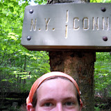
June 5 NEW ENGLAND!!! Crossed into Connecticut, and passed the largest oak on the AT.
June 6, Lauren (a college roommate) came to pick me up and I'm spending the night at her place for a nice relaxing evening.
Editor's Note: New England already!? Time for another round of superlatives! Get your submissions in now, via comment or email.
Also, two new verses have been added to Emily's song... go back and check it out
It's been hot and humid, making hiking a lot of work. A lot of swamp walks too, with mosquitoes of course. I hiked a marathon on June 1--26.7 miles...in some massive thunderstorms. It was a long day, but not too tough (I didn't want to do just a 12mile day). I crossed into New York on that day and climbed over the Lemon Squeezer. It was a narrow crack in the rocks, followed by a 7 foot rock wall. Challenging because it was so wet.
June 2 I climbed Bear Mtn...it was pretty crowded. On the way down I got interviewed by a local newspaper reporter about the new trail on Bear Mtn. Grand opening on June 5...so I was a couple days too early. The trail-side zoo was small but neat. The lowest point on the AT is right in front of the bear pen. New York is a deli walk--you can stop at a store almost every day for food. I actually started skipping some because I wasn't really craving anything store-bought.
June 3 the Cambridge Boys (Walleye, No Point, Nap Time) and I were at RPH shelter eating supper, and David Miller (Awol) showed up to take photos of the shelter. Nap Time recognized him (he's the author to our guide books!), and he gave us some trail magic--apples, hohos, water. An AT celebrity. Too bad we didn't think to get his autograph. I heard that Nature Boy and Toeman have summited Katahdin already!!!
June 5 NEW ENGLAND!!! Crossed into Connecticut, and passed the largest oak on the AT.
June 6, Lauren (a college roommate) came to pick me up and I'm spending the night at her place for a nice relaxing evening.
Editor's Note: New England already!? Time for another round of superlatives! Get your submissions in now, via comment or email.
Also, two new verses have been added to Emily's song... go back and check it out
Monday, May 31, 2010
New Posts
We've got a lot of new updates for you! The central portion of the trail is going well, albeit not very challenging.
Emily requests that no one plan to send care packages to Kent, which she will be arriving at on June 7th. She has put a forward on any packages from the past few mail sites and expects to receive them in Kent. After that, she will be stopping in Dalton MA June 11th. If you're sending mail, send it there. Remember, the post office will hold mail, so get your letters/packages in the mail with plenty of time to spare.
After Dalton, big brother Rob will be joining Emily on the trail for a while. Many adventures to ensue, I'm sure.
Maryland
Maryland--a flat, easy ridge-walk with VERY nice shelters (Potomac ATC has lots of $$). The hardest part was some super humid days. A lot of people did the 4 state challenge--VA, WV, MD, PA-- in one day. I chose NOT to. The trail in Maryland has a a lot of history...battle sites (civil war), and the first monument to be built for George Washington. Otherwise MD was not very exciting.
Half Way! (physically)
Entered PA May 15 and there was a series of cute little pairs of shelters (2 per site).
May 17 reached the Halfway Point...in the rain. The trail was still really easy. We met a guy heading south who told us the store at the halfway point was closed. This is where the traditional Half-Gallon Challenge takes place--eating a half-gallon of ice cream. We decided to eat lunch on the porch, and the store's door was open. Mellow Yellow ate a half gallon of Cherry Jubilee in about 1hr 30min. I ate 3/4 of a half gallon of chocolate...and was happy to keep it all down, followed by an 8 mile hike to the next shelter. In the rain. We wore fleece jackets and hats during the challenge because it was pretty chilly. Half the trip is over...but Maine still feels ages away. I don't think I'll feel more than half way done until I cross into New England. Stayed in Boiling Springs the next day because we got soaked in the rain. Great deal at the Allenberry Resort and Playhouse (they do dinner theater in the summer for only $25).
May 17 reached the Halfway Point...in the rain. The trail was still really easy. We met a guy heading south who told us the store at the halfway point was closed. This is where the traditional Half-Gallon Challenge takes place--eating a half-gallon of ice cream. We decided to eat lunch on the porch, and the store's door was open. Mellow Yellow ate a half gallon of Cherry Jubilee in about 1hr 30min. I ate 3/4 of a half gallon of chocolate...and was happy to keep it all down, followed by an 8 mile hike to the next shelter. In the rain. We wore fleece jackets and hats during the challenge because it was pretty chilly. Half the trip is over...but Maine still feels ages away. I don't think I'll feel more than half way done until I cross into New England. Stayed in Boiling Springs the next day because we got soaked in the rain. Great deal at the Allenberry Resort and Playhouse (they do dinner theater in the summer for only $25).
Pennsylvania
Southern PA was very flat and easy. It got rocky only in the last couple days, and it was a full variety of large boulders, rocks, and fist size angular cobble. All making it really hard to maintain a steady pace and not stress ankles/feet.
May 20 stayed at Peters Mtn. Shelter. There was a large black snake on the porch all evening. After dark it started crawling inside the shelter to try to get to a bird nest. I knew it wouldn't harm me, but it made me uneasy. LOTS of chipmunks on the trail--shrieking as the run away from you. I've also seen 3 rattlesnakes, all in the middle of the trail...they rattled when they saw me and refused to move, so I had to go off trail to get around them. One rocky ridgeline was COVERED in poison ivy. I tried to use my poles to keep the plants away as I hiked, but I'm sure I hit some. We'll see if I'm immune or not. It was impossible to avoid it.
May 22, Rather than staying at 501 shelter (right next to a busy road, full of boy scouts and thru hikers), I hiked an extra 6 miles to camp by a stream (near some more boyscouts). They saw me go by, and later came down to my site and said, "This may seem weird, but we have too much food, and we thought that since you're a long distance hiker you might want some extra fresh food. Here's a fresh, cooked trout". !! It was DELICIOUS!!! Gotta love trail magic!
"Rocksylvania" lived up to its reputation the last couple days in the state. It helped to pretend I was just walking along the rocky Maine coast, since there were few views from the ridges. There was a really nice climb out of Lehigh Gap (supposedly the hardest climb until New Hampshire...I guess it's going to stay fairly easy until then!). It was steep boulders and ledges...but a pretty short section. Then you get up onto a ridge-line that has been decimated by zinc mining (very little vegetation). The tics are out in full force, as are midges. I've given up staying in shelters because they kept me up a couple nights.
May 27, hiked into Delaware Water Gap with Mouse and Wazi. We got poured on right before town. Decided to split a motel room rather than stay in the crowded hostel (a good thing, because some drunken craziness occurred that night we heard). Showered, then went to Stroudsburg to see a movie (Robin Hood) for a break. Hung around in town until 2pm with Mouse, Yukon, and Litterbox. Good bye to Pennsylvania!!!
New Jersey
May 28, State #8 New Jersey. Rocky, but not as bad as PA. Way more views too. I've felt since the end of the Shenandoahs that the trail is just a connector between the southern mountains and New England. I wonder when I'll feel that the trail itself is a destination again. I'm getting tired of these long, view-less ridges and easy walking. I want to do some real mountain climbing again! Passed Sunfish Pond...the southernmost glacial pond on the AT. Very pretty, but plastered with No camping and No swimming signs. I finally met Rocker, Rooster, Snow White, 40oz (they've been just ahead of me the whole trip).
May 30, took the side trail to New Jersey's highest point, home to a large obelisk monument (like the Washington Monument in DC). I climbed up the humid tower but the views were almost the same as from the base. This afternoon the trail dropped off the ridge into farmland and swamps. I got to Unionville NY to resupply and camp in the park, only to find out there's no camping anymore. Luckily the Outhouse Hostel is in town. $10 donation for bunk, shower, laundry, dinner, and breakfast. Sweet deal, plus a southbounder I met on the road right before here paid for me. Trail Magic!!!
May 30, took the side trail to New Jersey's highest point, home to a large obelisk monument (like the Washington Monument in DC). I climbed up the humid tower but the views were almost the same as from the base. This afternoon the trail dropped off the ridge into farmland and swamps. I got to Unionville NY to resupply and camp in the park, only to find out there's no camping anymore. Luckily the Outhouse Hostel is in town. $10 donation for bunk, shower, laundry, dinner, and breakfast. Sweet deal, plus a southbounder I met on the road right before here paid for me. Trail Magic!!!
Monday, May 24, 2010
Edit of an Edit
Apparently when the hiking is easy, it goes faster. Although the previously updated schedule said Emily was a few days behind, she's made it all up and then some. She will probably be at the next few mail drops a few days early. We'll try to keep you as up to date as possible.
(Arrived Sunday May 23) Port Clinton, PA 19549
(Spent the night in the town's picnic pavilion, which is open to AT hikers.)
May 28 Delaware Water Gap, PA 18327
June 10 Kent, CT 06757
June 19 Dalton, MA 01226
June 20 Mt. Greylock
June 27 Killington, VT 05751
June 30 Hanover, NH 03755
July 3 Glencliff, NH 03238
July 10 Mt. Washington, NH
July 14 Gorham, NH 03581
August 2 Monson, ME 04464
August 12 End hike at Katahdin, ME
Address Mail to:
Emily Zimmermann
c/o General Delivery
Town, State, Zip code
Please Hold for AT thru-hiker
ETA date
In other news, she has been hiking a lot with Mellow Yellow, a guy from New Jersey. The hiking has been too easy, not much climbing. She and Mellow Yellow feel they are losing their hiking shape because it's just long ridge lines all day.
Emily, I really wouldn't worry too much. I don't see the rest of us getting 8 hours of exercise per day.
Friday, May 14, 2010
Updated Schedule
Waaaay back in the beginning we posted the estimated schedule for Emily's arrival at trail towns for mail drops. It's time to update that schedule. Right now Emily is sticking pretty close to the original plan. She is within 2 days of the old scheduled dates. Here are the most current estimates.
Est. Date / Location / Zip Code
(Arrived) May 12 Harper's Ferry, WV
May 21 Boiling Springs, PA 17007
May 27 Port Clinton, PA 19549
June 2 Delaware Water Gap, PA 18327
June 14 Kent, CT 06757
June 21 Dalton, MA 01226
June 22 Mt. Greylock
June 29 Killington, VT 05751
July 2 Hanover, NH 03755
July 5 Glencliff, NH 03238
July 12 Mt. Washington, NH
July 16 Gorham, NH 03581
August 4 Monson, ME 04464
August 14 End hike at Katahdin, ME
Address Mail to:
Emily Zimmermann
c/o General Delivery
[Town, State, Zip code]
Please Hold for AT thru-hiker
[ETA date]
Emily really enjoys home-made baked goods and other things she can't easily buy or make while on the trail. Letters are always appreciated.
Wednesday, May 12, 2010
Halfway! (psychologically)
[In her own words]
So I've now made it through the Shenandoahs. Everyone said the Shennies were easy and flat. Well, the trail was well-graded (few rocks or roots, nice gravel surface), but it wasn't flat. Relative to most of the rest of the trail, yes, but not flat. There were also not very many views. When the trail crossed the Skyline Drive (28 times in total) near an overlook you got a view. But I was hiking with some fun guys--Mellow Yellow and Sockburn. Also known as the Shenandoah National Petting Zoo, I saw a lot of deer who were not timid of people. Lots of squirrels. And 3 bears...cubs. They were up a tree and ran down and away as I approached. My attempts at "yogi-ing" (getting free food from non-hikers by looking hungry) failed. Partly because some of the campgrounds weren't open yet, but mostly because not many people were around. I did stop at one of the many trail-side Waysides (rest stops/cafe/gift store) and had a blackberry milkshake. It was excellent but severely overpriced.
May 10. A Trail Magical Day. I walked into Linden, VA to pick up my mail drop, and I had 5 packages!! The expression on the postal clerk's face as he handed them to me was priceless. I ate a lot of it on the spot, and shoved the rest in my pack for eating on the trail. Thanks everyone! Right before heading into town, there were a bunch of sodas and beers in the stream, but being 8am I decided to leave them for later hikers. I stopped at Manassas Gap shelter for lunch, where a group of Japanese day hikers were having a feast (including fish, seaweed wraps, etc.) and they gave me a short rib. I found a book at the next shelter (I had finished mine last night). Then there were oranges and root beer along the trail in the afternoon. Crazy amount of trail magic for one day.
May 11. 50 degrees and rain and gusty wind. I hiked across the Roller Coaster section (13.5 miles of steep ascents and descents) with tree branches blowing down all around me. The trail corridor is really narrow (hemmed in by private land), so the trail builders had little choice on where to put the trail). It was a harder section, but not too bad overall. I think the hardest part was crossing the 4 lanes of VA 7...in the pouring rain. I stayed at the Blackburn Trail Center (run by the Potomac AT Club), where they have a free hostel with wood stove (Heat!!), and the caretaker fed us spaghetti, home made bread, chocolate cake, and ice cream. It was a good night, even though I slept on the porch because it got way too hot inside.
May 12. Harpers Ferry. The psychological half way point of the trail. The first NOBO to come through this year was Nature Boy (remember him? he got stuck in the snow in VA, and was day hiking in GA when I started) on April 4. I am #55, and the 7th female (3rd hiking solo) to arrive. I toured the historic section of town this afternoon, had a huge cookies and cream milk shake, and am heading to my cousin Sarah's place in Baltimore tonight. I'm looking forward to a shower and laundry!! 1014 miles down, 1165 to go!
Monday, May 3, 2010
Emily Becomes A Song Writer
Hiking the AT
(“Battle Hymn of the Republic”)
Conquered Georgian mountains in just t-shirts and shorts
Then the rain came pouring down and caused us all to frown
But we kept hiking on…
Refrain
Hiking, hiking on the Appalachian Trail
Hiking, hiking on the Appalachian Trail
Hiking, hiking on the Appalachian Trail, in sun, wind, rain and hail!
We started our second state and it began to snow
Trudging up the steep slick slopes with no switchbacks to show
Then ice chunks started falling as the wind began to blow
And we kept hiking on…
Amid the rain we climbed up in the Smokies National Park
Wading through waist deep snow, we got completely soaked
And every night in shelters it got real cold after dark
And we kept hiking on…
After Hot Springs we hiked into the sweltering heat
Sweat was dripping down us from our heads to our feet
Our packs were heavy with the food that we were gonna eat
And we kept hiking on…
We trekked across Roan Mountain’s grassy balds in the sun
More than three hundred miles on the trail we’d done
Enjoying panoramic views in every direction
And we kept hiking on…
In Tennessee, state number three, into the spring we hiked
Along a long flat ridge called the Tennessee Turnpike
While many tried the Damascus Dash I still had a good food cache
And so I moseyed on…
We crossed into Virginia at the start of April
We’d hiked four-sixty miles across the many hills
But VA is the longest state, 500 miles will kill
So we kept hiking on…
The scenic VA highlands where the wild ponies graze
They’d lick your hands and arms and legs, they were so salt crazed
A grassy trail but Fatman’s Squeeze—the rocks were quite a maze
And still we hiked on…
Virginia’s trail, it tracked along the tops of many a ridge
In valleys climbing stiles into cow pasturidge
Crossing streams and rivers there always is a bridge
And we kept hiking on…
I slack-packed parallel to the Blue Ridge Parkway
The trail was well graded and my pack had little weight
A home-cooked meal awaited me to end every day
And so I hiked on…
Pennsylvania's trail had lots and lots of rocks
Halfway to Maine, but we weren't allowed to gawk
Along the ridges soared up high many a large hawk
And so we stumbled on...
New Jersey and New York had a rocky ridgeline
Maintainers had not been out yet in states 8 and 9
We passed at least one deli every day so we felt fine
And still we hiked on....
Lyrics By Emily Zimmermann
Tune by William Steffe
Friday, April 30, 2010
In Other News...
In Pearisburg Emily found a "career" landmark in her email: it's official, she's been awarded a fellowship at Memorial U of Newfoundland! Starting Sept. 1 she'll be studying cod with Drs. Fleming and Purchase. ( - and hiking awesome terrain in her free time!) So, along with doing town errands, she put together another scholarship application. [That's why she's not using her limited computer time to compose these entries herself.]
Congratulations Emily!
Congratulations Emily!
"Rolling Hills" of Southwest Virginia
[This update courtesy of Emily's mother, thanks for typing this one up!]
Emily phoned from Pearisburg on Wed., April 21. Yes, she did hike the half-mile side trail to summit Mt Rogers, VA's tallest peak at 5,729'. There was no view, covered with red spruce and "the northernmost natural stand of Fraser fir." [a superlative detail from the AT Guide] She seemed to regret that "there are no alpine zones," but there are plenty of gorgeous views along the ridgelines: the large deciduous trees that cover them aren't yet leafed out. Chestnut Knob on the 17th offered a great view of "God's Thumbprint," one of the nicknames for Burkes Garden, a five-by-ten-mile fertile valley completely ringed by mountains.
She's enjoying "Spring again, cold in the mornings, 60's during the day." Much of the treadway is on old overgrown logging roads, relatively free of rocks and roots. Hiking through rhododendron thickets "seems like hiking through someone's private landscaping," rather than natural growth. Her overall reaction to hiking southwest VA is, "I don't feel like I'm in mountains."
Switchback has been averaging 20 miles a day comfortably. Most nights she's in her tent, but at The Scales on the 14th she simply "cowboy camped" under the stars.
The evening's entertainment was a comparison of her night-sky-print bandanna to reality. Another evening's relaxation was provided by the music of pack guitar from Picker's tent interspersed with the sound of raindrops on her tent. By the 19th, the enthusiastically anticipated Trent's Grocery was on nearly every hiker's mind, but Emily wasn't suffering from any cravings for particular foods. [She doesn't like hot dogs or tomatoey pizza sauce, and the care packages have been "EXCELLENT!"] Her reward for that day's good hike was to set up camp a little early and read for a good long while next to the Falls of Dismal. [This one's nominated for Eeriest Place Name! - just happens to be on Dismal Creek.]
Superlatives
1. Favorite meal and/or snack: trail meal = Knorr broccoli and cheese pasta side, tuna or salmon with mayo and relish, chocolate for dessert; town snack = potato salad and swiss cake rolls
2. What is the best song or mantra that has found its way into yer head on th' trail? The Happy Wanderer is the most common song in my head, although I have different tunes every day. I’ve also composed one that gets stuck in my head a lot, to the tune of “Battle Hymn of the Republic”.
3. Who has been the most unlikely thru-hiker? Bulldog, who is trying to be the first blind guy to thru-hike the AT using just sticks (hiking poles)...although he has a camera man with him who is filming for a documentary...good intentions, and it sounds really challenging (what does he do at trail junctions???), but they skipped the Smokies and several other sections so far.
4. Most unusual hiker? (Please describe!) On March 20 I decided to tent camp at Locust Cove. I heard some voices down by the spring. I knew I was in the front of my thru-hiker group for that day, and a jeep trail led from the valley toward the spring, so I was unsure who might be down there on the weekend. Then three guys (plus a dog) walk up from the spring, wearing all camouflage clothing, carrying HUGE external frame packs with all sorts of gear hanging on the sides, hunting knives strapped to their belts, and one carrying an axe. The normal questions arise, how are you, where are you hiking to, etc. They said they were hiking to Fontana to go fishing. Hmmm. A pack of my fellow thru-hikers showed up, and we all pitched our tents. These guys didn’t even lay out sleeping bags for the night. Hard core!
5. Best Trail Magic? Unicoi Gap, Georgia (day 6). I’d been hiking in the rain for a few days. Coming steeply downhill to the gap I was thinking it’d be really nice to sit down out of the rain for a few minutes before climbing the next mountain. Wayne and Linda had a large tent, folding chairs, sandwich fixings, cookies, fruit, donuts, chips, soda, sweet tea, etc.
6. Best/Most Unusual Trail name? Little Spoon and Big Fork are a couple from Maine…we call them Cutlery. Grandma…who is a guy…he’s just really slow at packing.
7. Best weird conversation overheard in a shelter (or participated in)? March 17, Wayah Shelter. A conversation on the merits, characteristics, properties, and varied uses (of which there are many) of Livermush. Scruffy had packed some in from town and was sharing with everyone (yes, I tried some and it was good). For those of you unfamiliar with this southern delicacy, livermush is a processed meat product, similar to liverwurst, which can be eaten cold, fried, in omelets, etc. Use your imagination. We then proceeded to refer to Livermush for aobut 3 or 4 days afterwards, normally wishing we had some (it’d be really good in ramen, wouldn’t it?).
8. Greatest missed photo op? Documenting all the snow when I crossed into North Carolina, since my camera had gotten wet and wasn’t working, but more specifically it would have been March 14 at Muskrat Crek Shelter. Due to cold rain and snow, the shelter was full, with a couple tents pitched right next to it, and one guy (Picker) sleeping on the picnic table under the awning.
9. Largest mudhole? The entrance and floor of Double Spring Shelter in the Smokies (thanks to melting snow)
10. Friendliest hiker? Dr. John—a two-time thru hiker (’04 and ’07), he packed out some treats for me when he stopped at towns and I didn’t (milk, grapes, summer sausage).
11. Best shelter? Mountaineer Shelter in Tennessee (although I didn’t sleep there).
12. Eeriest place name? Dismal Creek Falls
13. Longest day? 21.2 mile on April 14 from Lost Mtn. Shelter over Mt. Rogers and the Grayson Highlands to a cowboy camp at The Scales.
14. Best mountain? Roan High Knob
15. Favorite section? Virginia Highlands/Grayson Highlands
16. Funniest moment? March 17, I had to push on to Wayah Shelter because there was too much snow at the campsite. I arrived late, in the rain, tired, hoping for a spot in the shelter. I hadn’t met any of the guys there before. I walk in and one guy (Scruffy) hands me a bottle filled with a warm, yellowish liquid…to warm my hands (turns out it was tea, but I didn’t know!). Then another guy (Sofa King) hands me a plastic grenade and tells me to pull the pin! (turns out it just makes noise). An interesting way to meet these guys, with whom I ended up hiking for a couple days.
Tuesday, April 27, 2010
New Trail Notes and Pictures
Today (Tuesday April 27th) Emily is in Bedford, VA at her Uncle’s house. She's taking a zero day, as in hiking zero miles, to recharge and upload photos. For the next few days she'll be doing some slack packing, which means to day hike and use the same sleeping location every night. In this case the sleeping location is a real house!
While not really a journal entry, Emily had this to say:
Keep thinking of superlatives and random facts you'd like to hear about. Right now the list is less than ten items, we can do better than that!
While not really a journal entry, Emily had this to say:
While walking all day (often by myself), I have re-written a couple songs. “Ode to Maintainers” (to The Man on the Flying Trapeze): “You maintain the trail with the greatest of ease; cut blowdowns in pieces move branches and trees; though just volunteers you’re as busy as bees; three cheers for the trails maintainers…ees; (where are you please??)”. For those of you familiar with Michael Cooney’s song about Bosco: “I hate blowdowns, they’re bad for you and me. When you try to walk them they’ll scrape up both your knees. Push through slowly or end up your belly, and then you’ll hate the blowdowns—just you wait and see!” The good news is the maintainers have been out now on most sections, so you can once again hike (rather than clamber) along the trail.
Keep thinking of superlatives and random facts you'd like to hear about. Right now the list is less than ten items, we can do better than that!
So after Damascus:
MAN was my pack heavy on that uphill climb out of town (yes, it is always uphill after town stops). I’ve definitely gained a hiker appetite…so trying to carry 8 days of supplies was a challenge (but still possible). I did my first 20 mile day on the 14th, and have done several since. I climbed Mt. Rogers, the highest mtn in VA. No views, but the summit is covered with Fraser firs, so I felt like I was on a real mountain. Most mountains/ridges down here have large deciduous trees so it feels like low elevation to me, and all the rhododendrons make me feel like I’m walking thru someone’s tropical shrubbery garden. The VA highlands and Grayson Highlands were beautiful. Grassy ridges (lots of views), rocky trail…and wild ponies. They are eager to be scratched, and love to lick the salt off sweaty hikers and their gear.
April 15
500 miles hiked so far. The night before Frost, Picker and I had a celebratory campfire. The trail so far in Virginia has been a lot of ridge walks, and then it dips into valleys and crosses cow pasture. I’ve climbed over a lot of stiles (wooden ladders over fences), and even had to shoo cows off the trail. Definitely a difference feel than the Maine AT.
April 17
Met some maintainers (Piedmont ATClub) building rock steps—they asked if I wanted to help them collect rocks, and then suggested I take some back to Maine (or at least take a Pulaski back). I declined. I also had to convince them I was from Maine, since I don’t really have much of a Maine accent. The next day two guys (Pine and Dreamcatcher) tried a 50 mile day. Turns out they only did 47 b/c of bad signage, and they were sore for a couple days after…but they said they’d do another 50 again. Crazy. I like 20 mile days just fine.
April 21
Ducked into Pearisburg to resupply, but decided not to spend the night (false rumor that the hostel was closed) so I camped a couple miles out of town. Met up with a new group of hikers: Mellow Yellow, Cookie Monster, Sockburn (from Germany, he burns his worn out socks), Hobbot. The birds are singing around 6:15 in the morning, so I’m getting early starts. Lots of birds out, lots of flowers (trees and shrubs too), and high humidity. Dragons Tooth and McAfee Knob are highlights of the non-descript trail. After hiking miles along view-free ridges, large rocky outcrops are a welcome sight, especially when the trail goes over/through them. We spent an hour on McAfee knob, but some ominous thunderclouds sent us to the shelter before sunset.
Saturday, April 17, 2010
The things I do for you...
Given our latest bout of failed technology, we've had to circumvent the problem in a most creative way. The following is a series of trail notes, but you have to understand how they ended up in their current format.
Emily called her parents on Monday April 12th. She gave them some kind of summary for her days, while her mother hand wrote notes during the phone call. Next Barbara typed up the notes, but lacking an internet connection herself, printed them out and took them to the library. There, the pages were scanned into a computer to be sent to yours truly. The issue with scanning is that the scanner makes a picture file, not a text file. So even though I received the notes, I still had to type them up from the picture because you cannot copy and paste the text out of a .jpeg file.
So here were are, in the 4th rendition of the journal entries. If you spot any grammatical errors, please send an email and I'll get it patched up. That goes for any entry. You can also sent me suggestions for improvements to the site, or things you'd like to hear about.
Finally, keep suggesting superlatives! It's completely free to comment, and easy too.
Days 26 - 38
April 1 (Day 26)
A brief conversation with a couple day hikers brought out an excited “Oh! The blueberry pie at.... that place...” “Yeah, Helen's.”
The ridge line over Big Fire Scald Bald was rocky and exposed ledge. Trail notes warned of an 8 foot vertical scramble requiring the use of hands. Emily met a SOBO (SOuth BOund hiker) who earnestly advised that she avoid it by hiking the bad weather bypass. Emily did not follow his advice. That night she wrote in the Shelton Graves register, “That was a nice taste of NH and ME, but where was the so-called 'scramble'?” Not trying to be a wiseguy, but just letting NOBOs (NOrth BOund hikers) know what's ahead.
April 2 & 3
“Why am I sweating when I'm going DOWNhill?” Someone said it was 83 degrees; another source claimed it was 87. Early spring flowers are blooming, but there are no leaves yet on the trees. When she needed to rest, she'd find a tree with a big enough shadow that she could be entirely out of the sun. After a while, she said, “It felt like my shadow didn't want to leave the shade.” and, thinking further of Peter Pan, “Wouldn't it be nice if we could hike in our own shadow all day!” Since that's not an option, daydreams of ice cubes, ice cream, and SCUBA diving in the Gulf Of Maine kept Emily hiking through the heat.
Spring weather on the AT is just as changeable as the terrain. Hiking over Big Bald was so windy that, leaning into the wind, she could feel her pack lurching sideways. Brown grass, brambles and hawthorns reminder her of Oregon. She spent the night in Erwin, TN.
April 4
Today's hike ended “kinda like Maine”. Emily camped on Unaka Mt. Covered with red spruce that “smelled really nice.” There were some scraggly blowdowns to negotiate: “You know what THEY'RE like!”
April 5
This 18.9 mile day ended after a 2000 foot ascent to the highest shelter (6,275 feet) on the AT, Roan High Knob, TN. The last mile of trail was covered with a foot and a half of rotten snow over an inch and a half of flowing water. [We spelled that out so there would be no doubt in your mind about how wet and messy it was!] Since she couldn't avoid breaking through it, Emily channeled her frustration into “stomping the snow to oblivion” thinking it might be helpful to hikers following her.
April 6
Leaving Roan High Knob was nasty, cold and messy on a muddy trail that had more water running down it than some of the streams she surveyed in OR last summer. It seemed there were blowdowns every ten steps! Grassy balds later in the day gave a reward of really nice 360 views. Emily investigated a box of pamphlets promoting an adopt-a-goat effort: when the grass turns green goats are brought here to graze, preserving the grassy balds by preventing blackberries from taking over. That night she camped on the NC/TN State Line at Doll Flats [Editor's note: The AT runs along the border of NC and TN for many miles, often crossing back and forth. Emily is not back tracking or lost, people just thought the mountains made a nice state border at that point.]
April 7
Our favorite experienced map reader and trail finder was confused! The original AT went straight up over and down the ridge lines. Apparently the atmosphere in the neighborhood of the Buck Mt Road gave cause for relocation of the trail, accomplished with a section of “ridiculous” switchbacks that cross and re-cross the original trail. The problem is that the original blazes aren't covered up, so a hiker can find the familiar white blaze in ALL directions at some intersections. Sometimes a few “skinny little sticks” were discernible as blocking the old pathway. Emily's guide was to know whether she should be going uphill or down, rather than going along with other hikers.
April 8
The day brought some rain, but Laurel Fork Falls is “really really pretty.” By the end of this day, Emily had hiked a total of more than 400 miles. This night at Laurel Fork shelter was her first encounter with inconsiderate hikers: oooh and is she ever grumpy when her sleep is interrupted for no good reason! Bears beware, there's a sleep deprived Emily in these parts.
April 9, 10, 11
Emily took it easy these days: she wanted to be in Damascus, VA on a Monday rather than a Saturday or Sunday, because of business hours. So in spite of the long, flat ridge line from Erwin or Hampton TN, which bears the nickname “the Tennessee Turnpike,” she didn't cruise. Some call it “the Damascus Dash.” Trail gossip said that one guy pushed 50 miles on 12 Snickers bars and ended up paying for it with an unplanned day in Damascus. Since Emily's not traveling that fast, she's spotted turkeys, deer, a barred owl, a snake, and robins, juncos, wrens, and thrushes. She can't name the flowers, but several remind her of Maine varieties.
April 13
After a refreshing resupply in Damascus, VA, 463.5 miles from the starting point of Springer Mt GA, Emily is “heading out to rack up some big mile days!”
Monday, April 12, 2010
Technology Failure
Sad day. Emily is in Damascus VA, right this very minute, but can't upload any pictures or journal entries. Woe is us.
What we're going to do while we wait for a techno-miracle is compose a list of superlatives for the first 500 miles. Things like longest day, tallest mountain, best day, funniest moment, best granola bar...
That's right, I said "we" as in all of you reading this. Leave a comment with the superlative you'd like to see the answer to. I'll make sure Emily gets the list and we'll get you a shiny new blog post in return, how's that sound?
3,2,1 GO!
PS. Approximately 7 days until Pearisburg VA (zip 24134) mail drop, and 21 days until Linden VA (zip 22642) mail drop. Address any mail/package:
Emily Zimmermann
c/o General Delivery
[town, state, zip code]
Please Hold for AT Thru-Hiker
ETA [date]
Thursday, April 1, 2010
Emily's Own Notes
Today's posts are a series of Emily's own trail journal entries, painstakingly transcribed from pictures taken of her trail journal. You may now all "oooh" and "ahhh" appropriately.
Day 14 3/20
Started the morning with breakfast at the restaurant – sweet potato griddle cakes (gooey), eggs and sausage. The Nantahala River is about 44 degrees. Climbed from 1700' at the rive to 5062' on Cheoah Bald – moderate terrain with a few steep bits. Nice view of the river from the Jump Up. I could even hear the tourist train's whistle. Had lunch on Swim Bald (wooded). First register in a shelter in NC at Sassafras Gap. Sofa caught up to me there – he is starting to have shin splints. The view from Cheoah Bald south was lovely, especially thanks to the folding lawn chair on top. Mountains to the horizon were blue and hazy. Steep ridges, pointy peaks. I hiked 10.5 miles to Locust Cove Gap to tent camp there.
Day 17, 3/23
Nice night in the Hilton, despite one loud snorer. Dragged all morning with low energy, everyone was passing me. Started out cold, cloudy. Hiked into the clouds and then the sun burned thru right in time for Shuckstack Mtn. I only climbed up one tier of the wooden stairs of the tall narrow tower, but the views were excellent. Climbed more than 3000 ft today. Almost stayed at Mollies Ridge, but it was such a GORGEOUS day I decided to move on. Had a snack and got a nice surge of energy to cruise (singing and whistling Colonel Bogey Bridge over River Kwai) to Russell Field Shelter, 13.8 miles. The shelter is stone, with a chain link fence on the front. Photos of : Fontana Lake, AT sign (green is common in NC), Fontana Dam, Below the dam, me entering the Smokies, Fontana Lake, Hollywood disappearing into the mist, Smokies, view from Shuckstack Mtn, Firewardens cabin remains, Russell Field Shelter. Tonight at the shelter: Picker, Cornpatch, Nate-dog, Thrasher and Turkey, Pace car, Guidefoot and Dad, Dr. John (a geology major who's been to Norway and Iceland).
Day 18 3/24
Hiked 16.4 miles today. Glorious weather – I think my arms are sunburned again... I should probably get some sunscreen in Hot Springs. Really nice views from Rocky Top *sings Rocky Top song* and Siler's Bald. The trail was slushy snow or soupy mud most of the day. Lots of snow from Derrick's Knob Shelter to Double spring Gap. I had a 1 hour lunch at Derrick Knob – nice stone shelter with plexiglass sky lights (so is Double Spring). Nate-dog, Picker, Cornpatch, Pace Car, Guidefoot, and Boomhouer hiked with me til lunch, and Mike. I caught up to Dr. John in the pm and hiked with him thru the snow. Saw my first slug this morning. First fir trees too on Jerkins Ridge (Fraser firs and spruce). Really pretty. Nice views of Clingmans's Dome. Tonight with Picker, Hollywood, No Point, Wanderer and Walleye, Dr John is texting.
Day 19 3/25
13.8 miles to Icewater Spring Shelter. In snow all the way except for half mile near Newfound Gap. Snowed on Clingman's Dome, sunny and rain at the same time on the way down. Windy all day. Cold evening with rain. Hollywood, Picker, Mike, and 3 other guys plus 3 section hikers in for the night. 1972 miles to Katahdin!
Day 20 3/26
Hiked 12.6 miles in the snow and ice and wind and rain to Tri-Corner Knob Shelter. I started in the rain, so I zipped down to shorts, then ended up on an exposed and windy ridge for a while. BRRR! Lots of firs and spruces, beautiful ridge walk, but no views because of the clouds. I want to come back to the section in snow free weather. Got to the shelter ~ 2:30, crawled into my sleeping bag to warm up. Crawled out ~ 6:30 for dinner. The sun had come out and all the grees are sparkling with ice. Very pretty – it's like the diamond forest in 12 Dancing Princesses. Springer Mtn to Fontana = 7% of AT hiked, 50% of hiker drop out by then. Highest point on AT is Clingman's Dome, 6625'. AT runs for 35 miles without dropping below 5000 ft (that's why it's so cold and snowy!) Normally when I approach hikers from behind I click my poles together to let them know I'm there. Today my poles iced up so I couldn't click them.
For those following my trip who aren't backpackers, here is a sample day of winter hiking (like my first 4 days in NC and the Smokies): Wake up ~ 7am, Grab fleece jacket and gloves from inside sleeping bag. Option A – scurry to the privy ASAP. Option B – find head lamp and put in contact lenses. Next, take off long johns and put on pants (also kept in sleeping bag). Take off wool socks, cover up any blisters or “hot spots” (potential blisters) with mole skin, gauze, or duct tape. Put on socks from the day before (from sleeping bag). Go to privy. On way back to shelter, retrieve food bag from bear cables. Get pot, stove, fuel from pack (which was used as a pillow) and cook 2 packets of instant oatmeal for breakfast. Pack up everything and strip down to tee-shirt and long sleeve shirt, fleece hat, shorts, knee high gaiters, boots, and yaktrax. Get hiking ASAP because it's COLD! Hike ~ 30 minutes then trade hat for bandana (around neck since the night before). Hike for 7-8 hours, stopping for lunch if it's nice, or snacking on the way if it's cold. Roll into a shelter in the afternoon after hiking 12-15 miles in snow. Claim a spot with my sleeping pad, fill my water bag and treat water with chlorine drops. Refill hydration bladder and small nalgene. Visit privy, change out of boots and wet socks. Put on long johns, pants, dry socks, long john top, long sleeve shirt and fleece jacket (plus rain pants and jacket if it's really super cold). Set veggies, etc, to soak in pot while I spread out sleeping bag and get ready for the night. Cook dinner followed by hot cocoa. Visit privy one last time, crawl into sleeping bag THEN strip down to long johns. Read for a bit and finally sleep. Repeat the next day. =)
For those following my trip who aren't backpackers, here is a sample day of winter hiking (like my first 4 days in NC and the Smokies): Wake up ~ 7am, Grab fleece jacket and gloves from inside sleeping bag. Option A – scurry to the privy ASAP. Option B – find head lamp and put in contact lenses. Next, take off long johns and put on pants (also kept in sleeping bag). Take off wool socks, cover up any blisters or “hot spots” (potential blisters) with mole skin, gauze, or duct tape. Put on socks from the day before (from sleeping bag). Go to privy. On way back to shelter, retrieve food bag from bear cables. Get pot, stove, fuel from pack (which was used as a pillow) and cook 2 packets of instant oatmeal for breakfast. Pack up everything and strip down to tee-shirt and long sleeve shirt, fleece hat, shorts, knee high gaiters, boots, and yaktrax. Get hiking ASAP because it's COLD! Hike ~ 30 minutes then trade hat for bandana (around neck since the night before). Hike for 7-8 hours, stopping for lunch if it's nice, or snacking on the way if it's cold. Roll into a shelter in the afternoon after hiking 12-15 miles in snow. Claim a spot with my sleeping pad, fill my water bag and treat water with chlorine drops. Refill hydration bladder and small nalgene. Visit privy, change out of boots and wet socks. Put on long johns, pants, dry socks, long john top, long sleeve shirt and fleece jacket (plus rain pants and jacket if it's really super cold). Set veggies, etc, to soak in pot while I spread out sleeping bag and get ready for the night. Cook dinner followed by hot cocoa. Visit privy one last time, crawl into sleeping bag THEN strip down to long johns. Read for a bit and finally sleep. Repeat the next day. =)
Day 21 3/27
Woke up this morning to COLD! My boots were frozen! The ice was glittering on all the trees on the North side of the ridge and the wind was blowing chunks off. The trail was covered in the chunks – it was like walking through an inch of ice cubes. The usn was out all day. I hiked .6 miles to the Mt. Cammerer fire look out – gorgeous 360 degree views of the Smokeis, the valley to the North and West, etc. A bunch of day hiker were up there. Right before Cosby Knob I dropped below the snow line for the rest of the day. The birds were singing, I saw a snake and a snail – it's spring! Tonight = 2600' above sea level – Davenport Gap Shelter – 14.8 miles and 1.2 side trail to tower. Picker, Hopi, Hollywood, and Mike at the shelter.
Friday, March 26, 2010
Side Notes and Pictures
First, to Phil, yes Emily has a trail name. Emily has been "Switchback" for many years. She choose the name as her camp name while working for Natarswi Girl Scout Camp, at the doorway to Baxter State Park (Maine). Unless she gets dubbed something else by her trail-mates, I suspect it will always be Switchback.
Next, for anyone who missed Rob's comment on the previous post... Emily has been accepted into the Memorial University of Newfoundland for post-grad studies in marine biology. YAY! I believe she is still waiting to hear from a few other schools before a final decision is made though.
And finally, what we've all been waiting for... Pictures!
(Hover on the little yellow figure in the bottom left, then click "AT Hike" to go to the photo album online - you can see the pictures bigger there)
Sunday, March 21, 2010
Trail names
So far Emily has been hiking with Kashmir, Ghost, Red Hawk, Yanni Stoner, and Terrapin & Moonshine. She's been leap frogging with a hiker from Scotland, by the name of Stuart, and he's agreed to email some pictures. Also a memory card may be making its way to the media interpreters by mail, so pictures may be soon - hooray!
Total millage is 135, and mostly in a foot of wet snow. That puts her well into North Carolina. Next package drop is Fontana (mile 162), see the previous post about package drops for the address.
Looking ahead, the Smokies are coming up. Emily estimates it will take her 12 days to get through. The Smokie Mountains National Park will be miles 163 through 234, for a total of 71 miles in the park. On the other side of the park is Tennessee. The word is that a trail maintenance crew has been up in the area to clear out some blow downs so hopefully the trail will be packed down and the walking will get easier.
Sunday, March 14, 2010
Rain, Rain...
Saturday, March 13, about 4pm, Emily called from the Blueberry Patch Hostel in Hiawassee, GA, while her sleeping bag dried near the wood stove.
On Thursday she had hiked 11 miles in rain to Low Gap, astounded by the amount of trash she's seen along the Trail and in shelters. She's not preachy, but indoctrinated in Leave No Trace ethics and accustomed to more pristine trails in Maine and New Hampshire, she was moved enough to write about it in one of the Trail registers.
Friday's 15 mile hike in more rain, and thunderstorms, was tremendously brightened after a steep descent from Blue Mountain: at Unicoi Gap there was a truck draped in a banner advertising AT Trail Magic, a generous array of goodies that don't travel well in packs, including a Tastee Cake (spelling?) that Em was enjoying while she talked to me on the phone. Thanks to Linda and Wayne of Cleveland, GA, for the boost! It helped ease the hike over Tray Mountain, "treacherous," Em said, on both sides of the peak: clear ice patches interspersed with remnant patches of crunchy snow. During the night at Tray Mt shelter, a huge thunderstorm produced such bright lightning that, with eyes shut, it seemed as bright as daylight.
Saturday the 13th: 11 miles in rain and sleet, around and through a lot of blowdowns. Apparently it's too early for maintainers to have been able to work on their sections. This morning she woke up cold. After three days and two nights in the rain, with high temp's maybe 54 degrees, drying gear inside the sleeping bag at night produced condensation. She said,"You don't take many breaks. You just want to hike to your base for the night and get out of the rain." Her legs are fine, the one blister is no worse, a couple hot spots are under control, and her spirits are very good. She came off the Trail at Dick's Creek Gap, where a hiker had just given up his seat on a shuttle in favor of an alternate plan, so Em hopped in and got a free ride to Hiawassee. There weren't many other hikers in the hostel needing drying space, so she was able to dry out her tent and fly.
Sunday, March 14, still raining, but back on the Trail to cross the North Carolina border only nine miles ahead.
Wednesday, March 10, 2010
The Shake Down
[Transcriber's note: I can't quite bring myself to pretend to be Emily by using language such as "I" or "my" it just feels weird. Maybe if you didn't know I existed it would be easier. Anyway, I'm going to write in third person, and you're just going to have to deal with it.]
On day two, Emily put down another 10 miles and found a place to camp on the ridge line and spent the night in solitude. Apparently there is a wildfire off in the distance, because she told me she could see the smoke from her camping spot.
So far the weather has been warm enough to hike in shorts and a tee shirt during the day, but some rain is on the way and so is a cold front. =(
In the "good news" category we have several things to mention. First is that Emily experienced her first Trail Magic - brownies! A kindly day hiker thought ahead and brought treats to the trail. Also a bag of apples was found, the details of which I was not told.
On the evening of March 8th, Emily arrived at Neels Gap, 30.5 miles from Springer Mountain. She stayed at the Walasi-Yi Hostel for 2 nights. While in Neels Gap it's necessary for one to visit Mountain Crossings outfitter. This gear store and more is unique in it's position and catering to AT hikers. Going in originally for a new rain cover for her pack, Emily came out with quite a bit more. She got a gear shake down which includes first weighing one's pack.... Emily's weighed 50 pounds! Yikes! The experts at Mountain Crossings were able to help her pare it down to just 35 lbs. This included the (unexpected and slightly expensive) purchase of a new pack. It might be worth it though, if it saves your back and knees and feet and neck and arms and hips and...
No pictures yet, due to technical difficulties. If we were going for 'typical hiker' we should have gotten her a smart phone. Apparently everyone else is online whenever and where ever they want. But how good of a picture can you take with a camera phone? High quality pictures on the way.
Sunday, March 7, 2010
Day One, Mile One
On Saturday, bright and early, well actually dark and early, Emily boarded a bus to catch an over night train to get to Georgia. So the "Jet Plane" titled posting was misleading, sorry. The Hiker Hostel is kind enough to run a shuttle from the transit center in Gainesville to the hostel, where Emily arrived Sunday morning. There was a group of 5 other hikers being picked up at the hostel and being dropped off at the trail head by the shuttle, and rather than kick around all day waiting for Monday to arrive, Emily decided to hit the trail early!
First summit: Springer Mountain, elevation 3,782 ft. Woohoo! The climb was gentle, but a bit slippery and mushy. In fact, it went from muddy to slushy to down right icy. Sunday night's sleeping quarters were the Hawk Mountain Shelter, 7.6 miles from the summit. The weather at Springer Mountain was overcast and about 45 degrees. Not a bad first day.
First summit: Springer Mountain, elevation 3,782 ft. Woohoo! The climb was gentle, but a bit slippery and mushy. In fact, it went from muddy to slushy to down right icy. Sunday night's sleeping quarters were the Hawk Mountain Shelter, 7.6 miles from the summit. The weather at Springer Mountain was overcast and about 45 degrees. Not a bad first day.
Saturday, March 6, 2010
Leaving, on a Jet Plane...
Howdy all, "media interpreter" Liz here. Emily has officially left for the trail! Monday will be the first day of hiking. From here on out, most of the posts will be written by me, posing as Emily. She'll give me the details she wants to post, and I'll flush them out into a nice story for you to read. Occasionally Emily will have access to a computer and may do her own posts.
A word about pictures; we've tried very hard to figure out the best way to upload pictures as often as possible, but keep running into snags concerning how to upload the pictures. The plan was for Emily to call me a few times a week so I could blog for her, then when she hits a trail town, she would upload her pictures and I would deal with getting them posted. Some pictures may be retro-posted to go with their blog post. I am seeing what I can do about getting a full album somewhere on this site that would be updated whenever Emily uploads pictures. That way, you can click through as many as you'd like. Everything is contingent on the computers at the trail towns. We're trying, really.
Lastly, please forward this website to anyone and everyone you know who might be interested! We love comments and questions, so don't hesitate.
Looking forward to hearing from Emily sometime next week. The first AT posting: coming soon, to an internet near you.
Tuesday, March 2, 2010
Appalachian Trail
For those of you interested in mailing me postcards, notes, or small goodies along the way:
Emily's Tentative Appalachian Trail Schedule
***All dates are estimates and may change***
Est. Date / Location / Zip Code
March 8 Begin hike at Springer Mtn, GA
March 11 Neels Gap
March 21 Nantahala Outdoor Center
March 23 Fontana Dam, NC 28733
March 31 Hot Springs, NC 28743
April 13 Damascus, VA 24236
April 21 Pearisburg, VA 24134
May 8 Linden, VA 22642
May 10 Harper's Ferry, WV
May 19 Boiling Springs, PA 17007
May 25 Port Clinton, PA 19549
May 31 Delaware Water Gap, PA 18327
June 12 Kent, CT 06757
June 19 Dalton, MA 01226
June 20 Mt. Greylock
June 27 Killington, VT 05751
June 30 Hanover, NH 03755
July 3 Glencliff, NH 03238
July 10 Mt. Washington, NH
July 14 Gorham, NH 03581
August 2 Monson, ME 04464
August 12 End hike at Katahdin, ME
Address Mail to:
Emily Zimmermann
c/o General Delivery
Town, State, Zip code
Please Hold for AT thru-hiker
ETA date
Letters can always be sent to:
298 Great Cove Rd.
Roque Bluffs, ME 04654
(and they will be forwarded to me by my Trail Manager)
Tuesday, February 23, 2010
Franconia Notch...a little white


Monday, February 22, 2010
Counting Down
With a little less than a month before I hit the trail in Georgia, I decided I should get this trail journal up and running. I am currently in the middle of a year off from school. I graduated with a degree in marine biology in May, and I am hoping to start graduate school in fisheries science in September (I'll be on Katahdin before then!!). Hopefully some of the southern snow disappears before I head south. I've wanted to hike the Appalachian Trail since I attended camp at the base of Katahdin when I was 12, and now is my chance. Happy trails to everyone else hitting a trail this spring!
Try Again in August
Well, I tried to get a head start on the trail by heading south out of Caratunk, Maine. We made it out of the village and across route 201 (with loaded log trucks screaming past) safely. Someone had walked their dog to the crossing, and the snow was firm. The crossing did not look promising, with the canoe full of icy water, frozen to the bank. Hopefully it looks more plausible in August!!
 more plausible in August!!
Subscribe to:
Posts (Atom)