First, to Phil, yes Emily has a trail name. Emily has been "Switchback" for many years. She choose the name as her camp name while working for Natarswi Girl Scout Camp, at the doorway to Baxter State Park (Maine). Unless she gets dubbed something else by her trail-mates, I suspect it will always be Switchback.
Next, for anyone who missed Rob's comment on the previous post... Emily has been accepted into the Memorial University of Newfoundland for post-grad studies in marine biology. YAY! I believe she is still waiting to hear from a few other schools before a final decision is made though.
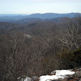
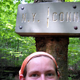
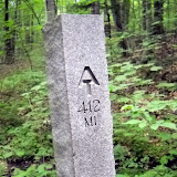
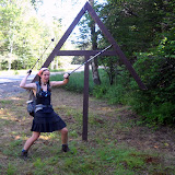
And finally, what we've all been waiting for... Pictures!
(Hover on the little yellow figure in the bottom left, then click "AT Hike" to go to the photo album online - you can see the pictures bigger there)
Friday, March 26, 2010
Sunday, March 21, 2010
Trail names
So far Emily has been hiking with Kashmir, Ghost, Red Hawk, Yanni Stoner, and Terrapin & Moonshine. She's been leap frogging with a hiker from Scotland, by the name of Stuart, and he's agreed to email some pictures. Also a memory card may be making its way to the media interpreters by mail, so pictures may be soon - hooray!
Total millage is 135, and mostly in a foot of wet snow. That puts her well into North Carolina. Next package drop is Fontana (mile 162), see the previous post about package drops for the address.
Looking ahead, the Smokies are coming up. Emily estimates it will take her 12 days to get through. The Smokie Mountains National Park will be miles 163 through 234, for a total of 71 miles in the park. On the other side of the park is Tennessee. The word is that a trail maintenance crew has been up in the area to clear out some blow downs so hopefully the trail will be packed down and the walking will get easier.
Sunday, March 14, 2010
Rain, Rain...
Saturday, March 13, about 4pm, Emily called from the Blueberry Patch Hostel in Hiawassee, GA, while her sleeping bag dried near the wood stove.
On Thursday she had hiked 11 miles in rain to Low Gap, astounded by the amount of trash she's seen along the Trail and in shelters. She's not preachy, but indoctrinated in Leave No Trace ethics and accustomed to more pristine trails in Maine and New Hampshire, she was moved enough to write about it in one of the Trail registers.
Friday's 15 mile hike in more rain, and thunderstorms, was tremendously brightened after a steep descent from Blue Mountain: at Unicoi Gap there was a truck draped in a banner advertising AT Trail Magic, a generous array of goodies that don't travel well in packs, including a Tastee Cake (spelling?) that Em was enjoying while she talked to me on the phone. Thanks to Linda and Wayne of Cleveland, GA, for the boost! It helped ease the hike over Tray Mountain, "treacherous," Em said, on both sides of the peak: clear ice patches interspersed with remnant patches of crunchy snow. During the night at Tray Mt shelter, a huge thunderstorm produced such bright lightning that, with eyes shut, it seemed as bright as daylight.
Saturday the 13th: 11 miles in rain and sleet, around and through a lot of blowdowns. Apparently it's too early for maintainers to have been able to work on their sections. This morning she woke up cold. After three days and two nights in the rain, with high temp's maybe 54 degrees, drying gear inside the sleeping bag at night produced condensation. She said,"You don't take many breaks. You just want to hike to your base for the night and get out of the rain." Her legs are fine, the one blister is no worse, a couple hot spots are under control, and her spirits are very good. She came off the Trail at Dick's Creek Gap, where a hiker had just given up his seat on a shuttle in favor of an alternate plan, so Em hopped in and got a free ride to Hiawassee. There weren't many other hikers in the hostel needing drying space, so she was able to dry out her tent and fly.
Sunday, March 14, still raining, but back on the Trail to cross the North Carolina border only nine miles ahead.
Wednesday, March 10, 2010
The Shake Down
[Transcriber's note: I can't quite bring myself to pretend to be Emily by using language such as "I" or "my" it just feels weird. Maybe if you didn't know I existed it would be easier. Anyway, I'm going to write in third person, and you're just going to have to deal with it.]
On day two, Emily put down another 10 miles and found a place to camp on the ridge line and spent the night in solitude. Apparently there is a wildfire off in the distance, because she told me she could see the smoke from her camping spot.
So far the weather has been warm enough to hike in shorts and a tee shirt during the day, but some rain is on the way and so is a cold front. =(
In the "good news" category we have several things to mention. First is that Emily experienced her first Trail Magic - brownies! A kindly day hiker thought ahead and brought treats to the trail. Also a bag of apples was found, the details of which I was not told.
On the evening of March 8th, Emily arrived at Neels Gap, 30.5 miles from Springer Mountain. She stayed at the Walasi-Yi Hostel for 2 nights. While in Neels Gap it's necessary for one to visit Mountain Crossings outfitter. This gear store and more is unique in it's position and catering to AT hikers. Going in originally for a new rain cover for her pack, Emily came out with quite a bit more. She got a gear shake down which includes first weighing one's pack.... Emily's weighed 50 pounds! Yikes! The experts at Mountain Crossings were able to help her pare it down to just 35 lbs. This included the (unexpected and slightly expensive) purchase of a new pack. It might be worth it though, if it saves your back and knees and feet and neck and arms and hips and...
No pictures yet, due to technical difficulties. If we were going for 'typical hiker' we should have gotten her a smart phone. Apparently everyone else is online whenever and where ever they want. But how good of a picture can you take with a camera phone? High quality pictures on the way.
Sunday, March 7, 2010
Day One, Mile One
On Saturday, bright and early, well actually dark and early, Emily boarded a bus to catch an over night train to get to Georgia. So the "Jet Plane" titled posting was misleading, sorry. The Hiker Hostel is kind enough to run a shuttle from the transit center in Gainesville to the hostel, where Emily arrived Sunday morning. There was a group of 5 other hikers being picked up at the hostel and being dropped off at the trail head by the shuttle, and rather than kick around all day waiting for Monday to arrive, Emily decided to hit the trail early!
First summit: Springer Mountain, elevation 3,782 ft. Woohoo! The climb was gentle, but a bit slippery and mushy. In fact, it went from muddy to slushy to down right icy. Sunday night's sleeping quarters were the Hawk Mountain Shelter, 7.6 miles from the summit. The weather at Springer Mountain was overcast and about 45 degrees. Not a bad first day.
First summit: Springer Mountain, elevation 3,782 ft. Woohoo! The climb was gentle, but a bit slippery and mushy. In fact, it went from muddy to slushy to down right icy. Sunday night's sleeping quarters were the Hawk Mountain Shelter, 7.6 miles from the summit. The weather at Springer Mountain was overcast and about 45 degrees. Not a bad first day.
Saturday, March 6, 2010
Leaving, on a Jet Plane...
Howdy all, "media interpreter" Liz here. Emily has officially left for the trail! Monday will be the first day of hiking. From here on out, most of the posts will be written by me, posing as Emily. She'll give me the details she wants to post, and I'll flush them out into a nice story for you to read. Occasionally Emily will have access to a computer and may do her own posts.
A word about pictures; we've tried very hard to figure out the best way to upload pictures as often as possible, but keep running into snags concerning how to upload the pictures. The plan was for Emily to call me a few times a week so I could blog for her, then when she hits a trail town, she would upload her pictures and I would deal with getting them posted. Some pictures may be retro-posted to go with their blog post. I am seeing what I can do about getting a full album somewhere on this site that would be updated whenever Emily uploads pictures. That way, you can click through as many as you'd like. Everything is contingent on the computers at the trail towns. We're trying, really.
Lastly, please forward this website to anyone and everyone you know who might be interested! We love comments and questions, so don't hesitate.
Looking forward to hearing from Emily sometime next week. The first AT posting: coming soon, to an internet near you.
Tuesday, March 2, 2010
Appalachian Trail
For those of you interested in mailing me postcards, notes, or small goodies along the way:
Emily's Tentative Appalachian Trail Schedule
***All dates are estimates and may change***
Est. Date / Location / Zip Code
March 8 Begin hike at Springer Mtn, GA
March 11 Neels Gap
March 21 Nantahala Outdoor Center
March 23 Fontana Dam, NC 28733
March 31 Hot Springs, NC 28743
April 13 Damascus, VA 24236
April 21 Pearisburg, VA 24134
May 8 Linden, VA 22642
May 10 Harper's Ferry, WV
May 19 Boiling Springs, PA 17007
May 25 Port Clinton, PA 19549
May 31 Delaware Water Gap, PA 18327
June 12 Kent, CT 06757
June 19 Dalton, MA 01226
June 20 Mt. Greylock
June 27 Killington, VT 05751
June 30 Hanover, NH 03755
July 3 Glencliff, NH 03238
July 10 Mt. Washington, NH
July 14 Gorham, NH 03581
August 2 Monson, ME 04464
August 12 End hike at Katahdin, ME
Address Mail to:
Emily Zimmermann
c/o General Delivery
Town, State, Zip code
Please Hold for AT thru-hiker
ETA date
Letters can always be sent to:
298 Great Cove Rd.
Roque Bluffs, ME 04654
(and they will be forwarded to me by my Trail Manager)
Subscribe to:
Posts (Atom)