Hey everyone,
Check out the January/February issue of AT Journeys (the ATC publication) for an article about the historic re-enactment on Katahdin! Kylie...you're in the photo, so make sure you check it out (I wish I had your e-mail/address)!
Tuesday, November 30, 2010
Tuesday, August 10, 2010
THANK YOU!!!
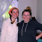
Now that my trip has reached an end, I want to thank everyone who helped me along the way. Everyone that I met in the trail community was so friendly and helpful! Thanks to everyone who sent me care packages along the way, or left words of encouragement on my blog site or with my parents. Just knowing that I had so many family and friends following my trip helped me through the tougher parts of the journey. Thanks to those who hiked with me and met me at road crossings, especially my parents. Throughout Maine I had personalized trail magic: they met me at every road doing the "trail magic hop", resupplying me, getting me dried out if it rained. Although I did the hiking, it's thanks to everyone who supported me that I made it all the way to Maine, and had fun along the way. And of course a HUGE thank you to Liz, my webmaster and blogger :-)
Monday, August 9, 2010
GAME 10
(Georgia to Maine, 2010 in hiker short-hand)
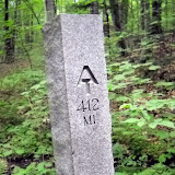
March 7 I stood on Springer Mountain looking north. August 6 I stood on Katahdin. 2,179.1 miles and 5 months of hiking through spectacular scenery, meeting wonderful people along the way. Many people hike the trail for profound reasons. In the words of Benton MacKaye, one of the founders of the trail, I hiked the trail “to walk, to see, and to see what I see”. Watching the seasons progress from winter to summer, from south to north, seeing the leaves unfurl, the flowers bloom, the mushrooms emerge. The first time I climbed Katahdin almost 10 years ago, and saw the white blazes headed south, I wanted to know what the trail looked like and what it passed through on the way to Georgia. Now, standing on Katahdin looking south, I know where the trail goes. I really enjoyed the hike, and I think the trail was a perfect length for me. I can't see myself doing another hike of this length, but I'm already reading about some shorter (maybe a month or so) long trails for my next excursion :-) However, right now I'm ready to move on to my next adventure—Newfoundland!
March 7 I stood on Springer Mountain looking north. August 6 I stood on Katahdin. 2,179.1 miles and 5 months of hiking through spectacular scenery, meeting wonderful people along the way. Many people hike the trail for profound reasons. In the words of Benton MacKaye, one of the founders of the trail, I hiked the trail “to walk, to see, and to see what I see”. Watching the seasons progress from winter to summer, from south to north, seeing the leaves unfurl, the flowers bloom, the mushrooms emerge. The first time I climbed Katahdin almost 10 years ago, and saw the white blazes headed south, I wanted to know what the trail looked like and what it passed through on the way to Georgia. Now, standing on Katahdin looking south, I know where the trail goes. I really enjoyed the hike, and I think the trail was a perfect length for me. I can't see myself doing another hike of this length, but I'm already reading about some shorter (maybe a month or so) long trails for my next excursion :-) However, right now I'm ready to move on to my next adventure—Newfoundland!
August 6, 2010
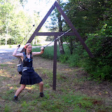
Up early to beat the crowds, Rob and I headed up the Hunt Trail for the last 5.2 miles of my Appalachian Trail thru-hike. The summit was in and out of clouds, but we had made arrangements with Pamola (Keeper of Katahdin, a creature with the head of a moose, wings and feet of an eagle, and torso of a man) for clear skies from 11 to 1, and he kept to his word. We met some thru-hikers coming down across the Tableland....including Picker!! It was really great to see him again. I hadn't seen him since Pearisburg, VA! At the summit Rob and I re-staged a historic photo of Myron Avery and his measuring wheel (I packed a converted bicycle wheel up the mountain with me), and attracted a LOT of attention. We came down via the Knife Edge and Dudley, probably the hardest way off the mountain, but it was fun.
100 miles to Katahdin
The last 100 miles of trail in Maine (the famed Wilderness) went quickly. I had hiked the section two years ago with Liz, so I remembered a lot of the trail, and I was in between thru-hiker bubbles (hiking alone). I had excellent hiking weather, watched the loons on numerous lakes, and even saw a bear! The last night I tented on the shore of a lake and watched the sun rise over the shoulder of Katahdin. It was magical. My folks all met me in Baxter State Park, where we waited a day for good weather. In the meantime my brother and I climbed Doubletop Mountain and went swimming at the natural rock slide at Ledge Falls on Nesowadnehunk Stream. We had many moose sightings, and watched a beaver swim up the stream across the falls, within 4 feet of us!!
Monday, August 2, 2010
15.1 Miles to Go
Emily is at Abol Bridge today...will do the next to last section tomorrow...Barb & Rob come Tuesday...looks like Mt. Katahdin will be later in the week to finish her 2,179 mile trek from Georgia!!!
Coming to you from the Appalachian Trail Cafe in Millinocket, Maine.
Coming to you from the Appalachian Trail Cafe in Millinocket, Maine.
Monday, July 26, 2010
Mountains of Maine
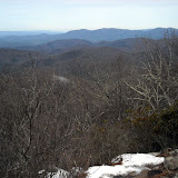
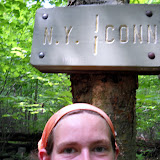
I had beautiful weather crossing the high peaks of Maine. Last time I hiked most of those peaks was up to 14 years ago (my first ever backpacking trip, over the Crockers and Sugarloaf!), so I had remembered the trail as being VERY tough. It definitely was rugged, but I had a lot of fun hiking through them. I saw a MOOSE on Spaulding Mountain ridge. I beat my dad to the trail work site just north of Rt. 27 near Stratton (and he only had to day hike 5 miles to the site. I walked 12 miles). We helped to install some new bog bridging with some other AMC/MATC (Maine Appalachian Trail Club) folks. It was fun to give back to the trail, while still on my thru-hike. My dad then joined me to cross Bigelow Mountain—my favorite in the state. We had gorgeous weather, but it was a little too hazy to see Katahdin. We even found the machete used by Myron Avery when doing trail work!! Myron Avery, of North Lubec, Maine, was one of the founding fathers of the Appalachian Trail. He is responsible for laying out most of the original trail in Maine, and for getting the trail into Maine in the first place (the northern terminus was originally going to be Mt. Washington, NH). Bigelow was Avery's favorite mountain, so when he passed away his family cemented his machete near the summit of Bigelow.
Flatlands of Maine
My dad hiked with me for about a week through the ponds and swamps. We heard lots of loons and saw lots of toads, frogs, and mushrooms. The blueberries are ripe—making a lovely addition to our morning oatmeal. There are amazingly few biting insects out this year. We stopped to admire several bogs and didn't get chewed up. We crossed the Kennebec River—a dangerous ford because of the hydroelectric dam upstream that can release large volumes of water. MATC has provided a canoe ferry (and ferryman) to help hikers across. We did have to ford the East and West Branches of the Piscataquis River...but they were easy. Knee deep, gentle current, warm water. I'm taking a zero day in Greenville with my parents before heading into the 100-mile Wilderness. I'm taking my time and enjoying the rest of my trip, so several of my northbound friends have caught up and passed me. It sounds like August 1 is a popular summit day, but I will be on Katahdin a few days after that.
Subscribe to:
Posts (Atom)